Passengers Mustering and Evacuation Process Automation System (PaMEAS) is the system tracking and monitoring the position of customers within the ship (in the various areas of a ship, from the lower decks, where the state rooms locate, to the uppermost levels, which include the promenade and activity decks) and automatically launching, in the case of an emergency, a pre-defined evacuation plan that will be communicated to passenger’s mobile phones. Maritime safety standards require that all passengers on board should have the ability to escape in the case of an emergency from which the ship cannot recover. The PaMEAS system implements this regulation by streamlining and automating the processes of mustering and evacuation, and by creating a mobile interface between the ship evacuation plan and the passengers. The System will be able to identify
the location of passengers within the ship, and based on this information, to provide augmented safety functionality and new types of evacuation services such as, a) High accuracy indoor people tracking and analytics functionality, b) Passenger navigation in emergency situations and, c) Mustering and evacuation monitoring in real time and, d) SAR (Search and Rescue) specific services that can be used by the dispatched rescue forces to search and find survivors, promptly approach and rapidly assist them). Essentially, PaMEAS is designed to apply a pre-defined (by the Project) ship evacuation plan, to provide automatic guidance in emergency situations with the use of a mobile application (which may be of great help when people should cross dark and smoked filled areas).
PaMEAS will seamlessly integrate, through specific APIs, with other PALAEMON back-end infrastructure systems and onboard tool and services, while building on top of existing ship IT infrastructure (e.g. Reservation and Check-in, Crew Management, Shipboard Property Management etc.). In fact, PaMEAS System will cooperates through APIs and connectors with other physical and cyber systems that are included in PALAEMON project infrastructure, specifically with:
i. MEV – Mass Evacuation Vessel: MEV Sensoring Tool has an interconnection with MaPEAS System
ii. SSS – Smart Safety System: MaPEAS receives evacuation scenarios from SSS – MaPEAS implements part of the DSS functionality, i.e. Communicate effectively with passengers during an emergency and Demonstrate the use of personal life-saving appliances
iii. AR – Augmented Reality Glasses for Ship Crew: MaPEAS System provides feedback to AR Core
iv. COncORDE – COncORDE Emergency Management System: MaPEAS provides aggregate information to COncORDER for global ship monitoring needs)
v. ITML – Enhanced data fusion and analysis techniques: MaPEAS provides information to ITML
vi. UAV – UAV Inspection Module: MaPEAS provides information to UAV (directly or through other PALAEMON IT Systems)
Essentially, the functionality of PaMEAS System is based on the deployment of a commercially available off-the-shelf (COTS) Indoor Position System, tailored to the needs of a passenger ship. An indoor positioning system (IPS) is a system to locate people and objects inside edifices where GPS stops working, by using the capacity of the telecom equipment to identify users (such as, for example, the ability of Wi-Fi Access points to know what device is connected), along with the information collected by typical sensing devices (such as beacons etc.) and by context-specific mobile apps, installed in mobile devices. By incorporating an IPS System, PaMEAS system will use the indoor tracking functionality available by these systems to create and deploy within the ship a new layer of service functionality consisting of passengers’ location monitoring for safety purposes, mustering and emergency navigation; and, enable the deployment of a unique service point for on-board safety coordination, from where passengers’ safety can be operated, verified and monitored (the indoor positioning functionality can be also used by the ship management, in regular time periods, to create new customer experience-based services, a possibility that creates an additional, important, investment incentive). Obviously, the System will be also able to monitor the location of seafarers, according to the applying legislation, and provide them critical information and real-time task-based guidance and in the case of an emergency.
As explained before, PaMEAS is designed to apply a (pre-defined) ship evacuation plan and provide guidance to passengers with the use of a mobile application (i.e. real time navigation) to improve the operational effectiveness of the mustering, evacuation and rescue processes. PaMEAS System is a flexible infrastructure which extends the functionality of the existing ship IT systems. It is made of
several network hardware and IT software components. Hardware refers to the part of the System that should be implemented in the different decks of a ship and includes: Wi-Fi Access Points, 4G(LTE)/5G Radio Dots, beacons and other sensors. Software refers to a software suite that will be deployed locally
Figure 13: PaMEAS Hardware & Software Components.
This proposal version was submitted by Philippe CHROBOCINSKI on 19/09/2018 15:36:06 Brussels Local Time. Issued by the Participant Portal Submission Service.
Marine Accident Response (subtopic B) MG-2-2-2018
PALAEMON page 18
(within the ship) and remotely (in the cloud), to process the collected information from the hardware components and provide location analytics, emergency navigation for the passengers and rules-based safety policy decisions for the ship management.
PaMEAS hardware: The hardware equipment implemented in the ship will follow the ongoing technology evolution path, by exploring two different technology trajectories (Wi-Fi16 vs 4G LTE/5G17) while studying and promoting their coexistence. In fact, PaMEAS will establish:
i. A core wireless infrastructure based on state of-the-art technologies, using mostly Wi-Fi Access Points, beacons and other sensors,
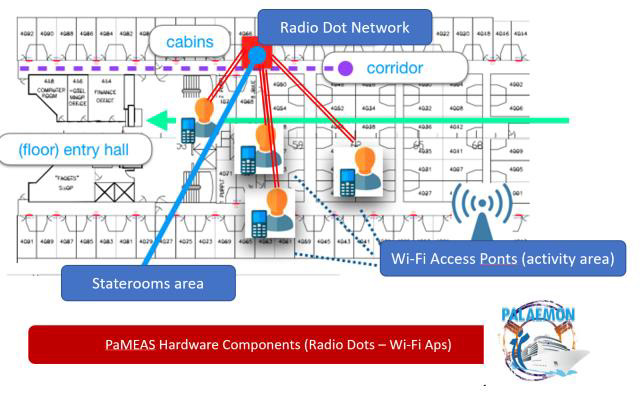
ii. An augmented wireless infrastructure that will complete the core infrastructure, a 4G LTE/5G Radio Dot Network18 (consisting of indoor small cells implemented in priority in the most difficult to monitor areas of the ship, such as decks hosting staterooms and corridors), in the objective to further improve people location accuracy and service efficiency.
Eventually, these two infrastructures may co-exist for a longer period, in a context where the core wireless infrastructure (Wi-Fi) will cover the activity decks of the ship, while the Radio Dot Network (augmented wireless infrastructure) serving the staterooms areas and the corridors leading to the passengers’ cabins (lower ship decks). The coexistence of these technologies will also allow for a safe transition from the state-of-the art to more advanced technologies, such as Radio Dots, which may however have a significant market penetration only in a few years from now, perhaps close to the end of the project.
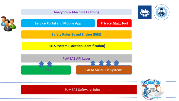
PaMEAS software: The hardware equipment will be completed with a software suite that offers to the ship management automatic people and objects tracking (i.e. position identification) based on the processing of information collected form network antennas, different types of sensors placed in the ship and mobile devices, along with: location analytics, navigation guidance in emergency conditions and automated mustering and evacuation, safety-related decision policies based on automated rules etc. A machine learning component completes the above suite, to offer the possibility of improving location efficiency based on the analysis of past location paths, essentially by identifying structures and routines hidden in users’ past locations. Finally, people privacy is ensured by a specific module that establishes user-control over the activation of location services, process certification in the case of an automatic launching of the location tracking software (in the case of an emergency), and transparent exchange of personal data between the user and the ship IT management.
The components of the PaMEAS software suite are listed below and illustrated in the following Figure: a) RTLS System (Location identification), b) Rules-Based Engine (RBE), c) Service Portal and
Mobile App, d) Privacy Management Tool, e) Analytics Engine and Machine Learning, f) PaMEAS System APIs.
Augmented Reality Glasses for Ship Crew (AR)
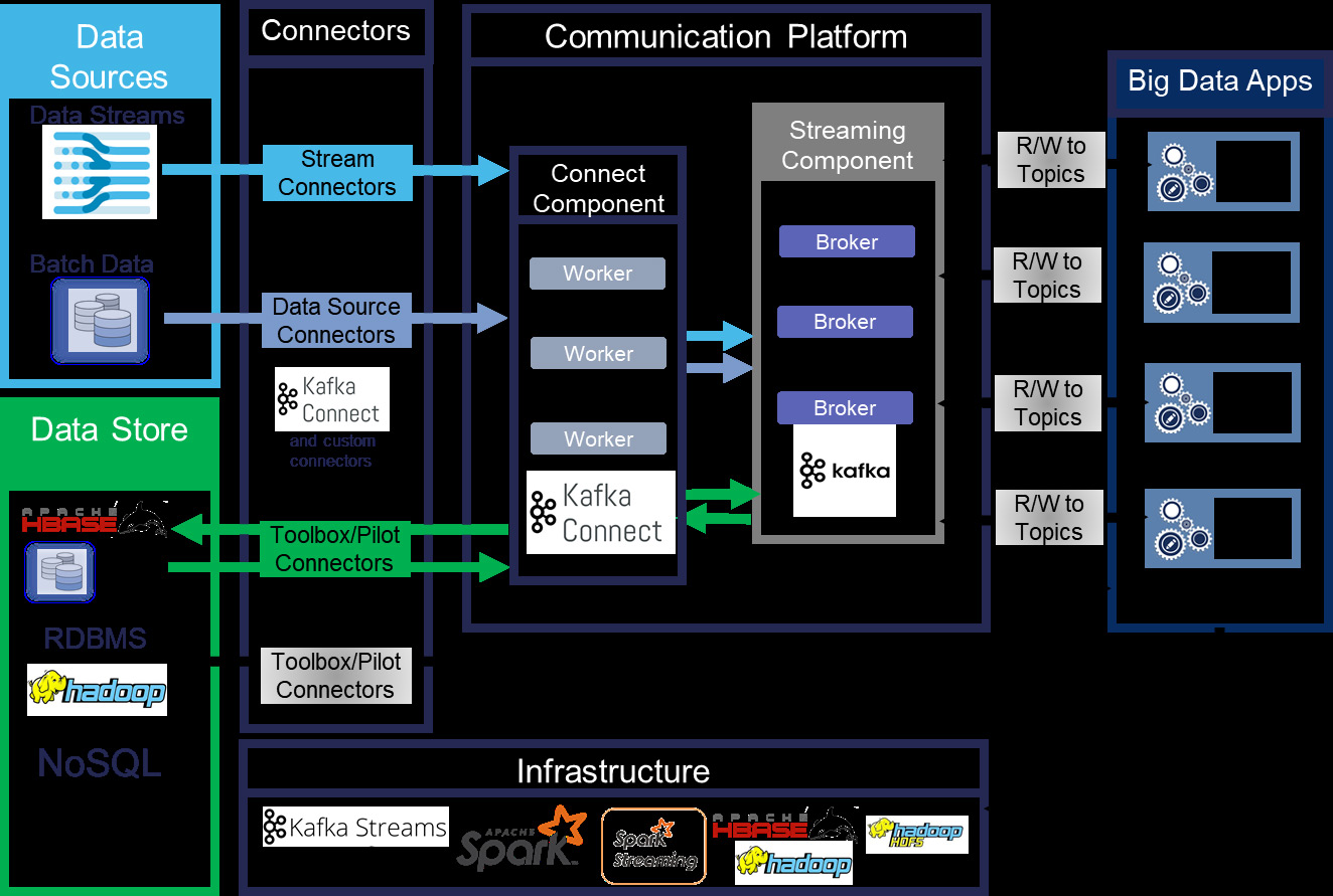
Interoperable Communication Platform
Enhanced data fusion and analysis techniques
Passengers Localisation
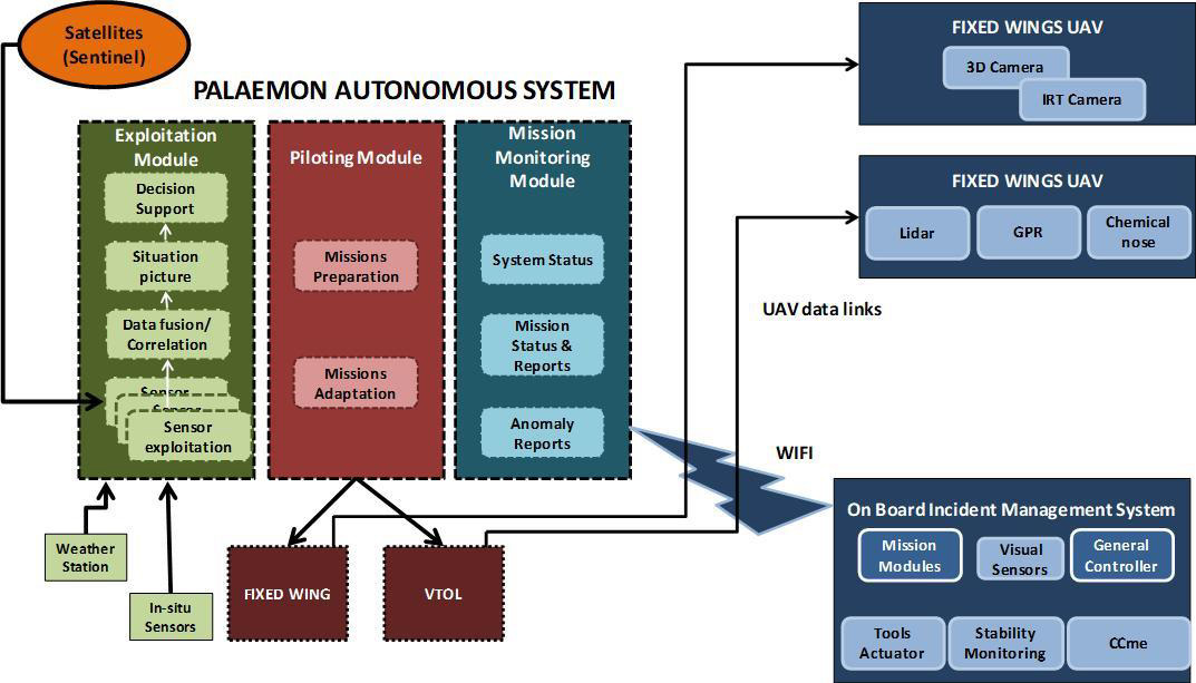
UAV Inspection Module
Data Management
Data Analytics Engine & Weather Forecasting Toolkit